
Revamping NPark’s Coast-to-Coast App
Project Details

Project Duration: 2-week sprint
Team: 4 UX Designers
My Role: User Research, Usability Testing and Project Management
- Conducted UX research to generate meaningful insights
- Synthesized and analyzed the data collected to drive design decisions
- Made design contributions to the overall concept
- Ensured alignment amongst everyone, and that the team kept on task
Tools: Figma, Zoom, Google Drive and Google Docs
The Problem
On 30th March 2019, the National Parks Board (NParks) launched the Coast-to-Coast (C2C) trail which is 36 km in distance and stretches from Jurong Lake Gardens in the west to Coney Island Park in the northeast.
To complement the trail, NParks introduced its C2C mobile application, which makes use of interactive augmented reality (AR) elements to provide users with a curated walking experience as well as an online trail guide.
However, since its launch in 2019, the C2C app has received unfavourable public reception.
The Challenge
To revamp the C2C app and improve its offerings for users, whilst ensuring alignment with the business goal.
*Please note that this is a conceptual case study and NParks has no involvement in this project.
The Solution
ExploreSG is a mobile app that provides users with concise and real-time information about the various trails and events happening across various Parks, Nature Reserves and Park Connectors in Singapore.
The Research Process
To understand the problem space, we took a holistic approach by conducting both primary and secondary research.
Our objectives for conducting various types of research
What We Learned
NParks’ C2C App
Based on the 227 app reviews found in the app store, we identified the pain points that users faced while using the app:
Limited to just the Coast-to-Coast trail
The directions on the app’s map were inaccurate and insufficient
The map was often not functioning properly
NParks
We researched on NParks’ website and realised the following about the organization:
NParks provides an array of offerings such as Events and Activities such as tours at their green spaces, Learning, Biodiversity and Gardening.
NParks’ goal is “to promote 'green' recreation as a lifestyle”.
NParks’ vision is to transform Singapore into a City in Nature by strengthening the connectivity between Singapore’s pockets of green spaces through the Park Connector Network and the Nature Ways by 2030.
Competitive Analysis
Our team did a competitive analysis on 3 popular trail apps and found that all 3 apps allowed their users to:
View a range of trail information
Search for information about a trail within the app
Provided an interactive real-time map for users to navigate
View the Feature Analysis
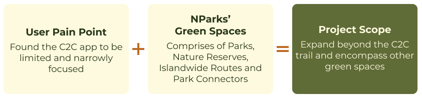
Project Scope
From the current research findings mentioned above, our team identified that the revamp app should expand beyond the C2C trail to encompass other green spaces in Singapore. Doing so would also be in alignment with NParks’ goal to “promote ‘green’ recreation as a lifestyle” and complement their 2030 vision.
Conducting User Interviews
As the team agreed that the scope of the app should encompass other green spaces, we conducted User Interviews with 10 individuals who have been to one of NParks’ green spaces before.
These individuals were aged between X to X, owned a smartphone, and is moderately tech-savvy.
We asked questions about:
Their experience when heading out to one of NParks’ green spaces.
Which green spaces in Singapore do they usually visit and why?
How often do they normally frequent these green spaces?
Who do they normally visit these green spaces with?
What could encourage them to visit new green spaces?
Synthesizing the Data
Using the Affinity Mapping technique to synthesize our research findings, we found the following insights:
All of our interviewees found the process of searching for information on green spaces in Singapore time-consuming and tedious.
8/10 of our interviewees found it difficult to access real-time information about a particular green space when they’re out.
People wanted information at their fingertips. This validated the need for a mobile app, which will enable people to easily access information whenever and wherever they are while being on the go.
Creation of Personas and User Journey Maps
Using the insights gathered from our User Interviews, we developed 2 personas and charted their journey.
2. Fauzi Baharid
Frustration: Finds that the information in the C2C trail app is insufficient and directions are unclear.
1. Samantha Wong
Frustration: Finds the process of researching before hiking is disjointed and time-consuming, as she has to get info from multiple sources.
Defining the Problem
The team came together to determine the problem statement and a “how might we” statement for each of the insights uncovered from our user interview.

Identifying the Solution
A brainstorming session was conducted based on the corresponding HMW statements. The 2 main functions of the app listed below have been chosen because of their alignment with both user needs and business goals:
Explore Function - A one-stop platform that allows individuals to search for information about a particular green space in Singapore easily.
Navigate Function - Provides individuals real-time information to navigate while they’re outdoors in Singapore.
Mapping the User Flow
Mapping out the flow for each persona enabled the team to visualize how the 2 main functions of the app will solve the persona’s problem.
1. Samantha Wong
Frustration: Finds the researching phase tedious, disjointed and time-consuming.
Solution: Explore Function
2. Fauzi Baharid
Frustration: Finds that real-time information in the C2C trail app is insufficient and directions are unclear.
Solution: Navigate Function
Identifying Features
With a clear understanding of the app’s user flow, the team collaboratively came up with a list of features via Google Docs, identifying features we thought would best solve the users’ problems.
View the app’s final list of features.
Information Architecture
The team took stock of all the various trails in Singapore and classified them into the following categories:
Parks and Nature Reserves
Islandwide Routes
Park Connectors
Ideation through Sketching and Wireframing
With a clearer understanding of the problem space, and the app’s main functions and features, the team did a sketching exercise. Everyone sketched how they envisioned the app to be and presented it to one another.
Afterwhich, feedback was provided and gathered to refine and combine the sketches into a singular solution i.e. the wireframes.
Prototyping
Conducting Usability Testing
Our team conducted usability testing with 10 users on the prototype.
Overall, the reception to the app was positive.
On average, we received a total of 4 out of 5 for overall satisfaction with the app.
After synthesizing the data, the biggest insight we gathered was that
8 out of 10 users were unaware that some icons were clickable and contained more information
We came up with 2 solutions to address this problem:
Reorganise the information page
We redesigned the information page so that important details can be seen across the screen rather than have them kept and hidden within an icon
Have onboarding instructions for first-time users
First-time users will be able to get a quick tutorial on all the tips they can gather within the app through 3 onboarding prompts:
1 . Real-time updates
2. Push notifications about trail information
3. A prompt to encourage users to create an account to join the community.
Final Design
Future Opportunities
Some ideas which we can explore in the future:
The Events and Activities could be a function by itself
During our Usability test, many users mentioned that they like the recommended events and activities, and they found them helpful.
Collaborate with Health Promotion Board and other Government Agencies
Gamification of the app c